Summer Watering Rules and Drought Status
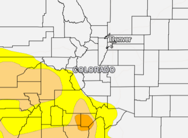

According to the National Integrated Drought Information System (NIDIS), 14% of the state is currently experiencing some level of drought with 13% in the Moderate Drought category, and 15.4% of Colorado is Abnormally Dry. The map featured above shows the drought conditions on August 29.

As of May 30, cumulative precipitation in the Colorado River watershed was tracking at 97% of average and the South Platte River watershed was tracking at 82% of average. Snowpack in the Colorado River is tracking at 98% of normal and is tracking at 81% of normal in the South Platte River watershed.
Denver Water’s supply reservoir contents as of May 30 are represented in the table below.
| Reservoir | Percent Full: Current | Percent Full: Historical Median |
|---|---|---|
| Antero | 96% | 100% |
| Eleven Mile | 102% | 102% |
| Cheesman | 86% | 95% |
| Marston | 76% | 63% |
| Strontia Springs | 87% | 93% |
| Chatfield | 92% | 58% |
| Dillon | 88% | 98% |
| Gross | 46% | 84% |
| Ralston | 87% | 87% |
| Meadow Creek | 45% | 77% |
The district will continue to work with Denver Water on monitoring the watersheds and will provide updates to our customers through our website and social media channels.